
Read our 2025 annual report


Knowledge Hub
 Blog
BlogHow Hazard Mapping is Strengthening Flood Resilience in Tana River County, Kenya
In Tana River County, Kenya, a new Hazard Atlas is helping the County Anticipatory Action Plan Technical Working Group move from broad flood warnings to more targeted preparedness, anticipatory action and longer-term climate resilience.
Every rainy season, communities living along the River Tana watch the water levels closely. Many families rely on the river and its fertile flood plains for farming and livelihoods, but more frequent and severe floods are increasing the risks they face.
For 14 years, early warning information has been available in Tana River County yet translating warnings into timely location-specific action has remained a challenge. County officials, humanitarian agencies and communities often knew that flooding was likely but lacked detailed information on which villages will be affected first, which roads would become impassable, which services were most exposed, and what actions should be taken before floodwater arrives.
Through the Zurich Climate Resilience Alliance, Concern Worldwide is supporting county-led efforts to strengthen disaster risk management, early warning and anticipatory action in climate-vulnerable areas of Kenya. In Tana River, the County Government, with support from Concern as part of the Disaster Risk Management Technical Working Group and in collaboration with national government actors, developed a comprehensive Hazard Atlas. The process brought together the National Drought Management Authority and county departments responsible for sectors including water, agriculture, livestock, health, lands and physical planning to consolidate local knowledge, scientific evidence and historical disaster data into one decision-making tool.
Over 5 days in June 2026, 25 county stakeholders came together to map the range of hazards facing communities across the county, including drought, floods, invasive species, disease outbreaks, conflict, and seawater intrusion, laying the foundation for improved hazard mapping. Attention was given to floods, as the most significant and recurring hazards affecting people, livelihoods and infrastructure.

Participants identified flood-prone areas, vulnerable populations and critical infrastructure across Tana River County (5 sub-counties, 15 wards) with emphasis on the impacts of the 2023 floods as a basis for the hazard mapping exercise, using evidence that 54.5% of the county's population was affected, 28,628 households were impacted, and six lives were lost. Participants also documented seven major roads cut off during flooding, 94 schools and 31 health facilities that became inaccessible, 9,584 acres of farmland destroyed, 177 livestock lost, and 53 settlement clusters representing 10,037 households. Beyond producing hazard maps, the workshop generated practical information to support county planning and preparedness and risk reduction.
The analysis also identified 20 ZCRA communities located within mapped flood hazard plains, with exposure to riverine flooding. This provides a clearer picture of where flood exposure is concentrated and helps guide more targeted preparedness, early warning and anticipatory action measures. While flood risk extends across the wider programme area, identifying these 20 communities’ highlight’s locations that require focused attention for riverine flood preparedness and risk reduction. The findings therefore provide an evidence base for prioritising community preparedness actions, strengthening last-mile early warning dissemination, and informing county planning and investment in flood resilience.
Examples of the Hazard Maps
Beyond producing maps, participants recommended strengthening routine monitoring of river levels and rainfall, improving community-based early warning systems in high-risk wards, using hazard information to guide land-use planning and infrastructure development, and pre-positioning emergency supplies before the rainy season.
The mapping process also enabled stakeholders to analyse how flooding interacts with and trigger secondary hazards including human and disease outbreaks. Attention is given to waterborne diseases such as cholera and typhoid and livestock diseases such as pneumonia and rift valley fever that in the past have increased following flooding due to contaminated water sources, cold weather, displacement of people and animals and disruption of sanitation and health services. This strengthened understanding of the cascading risk associated with floods and the need for integrated preparedness and early action across health, WASH and livestock sectors.
Participants highlighted how floods can damage water and sanitation infrastructure, contaminate water sources, increase disease outbreak risks, disrupt access to education, destroy crops and livestock, interrupt transport networks and markets, and heighten protection risks for vulnerable groups. This reinforced the importance of planning for the wider impacts of flooding, rather than responding only once communities have been affected. The workshop also considered how flood impacts can be reduced through initiatives such as the Eco-Village Cluster Resettlement Programme, which supports voluntary relocation from highly flood-prone areas to safer ground.
For county officials, one important outcome was the shift from viewing maps as technical products to using them as practical planning tools.
“Early warning is not just about knowing that a flood is coming; it is about knowing who will be affected, where they are located and what actions should happen before the disaster occurs.”
The Hazard Atlas provides a link between hazard information and decision-making. The current Atlas contains static hazard maps supported by narrative analysis, while the county is exploring a more interactive dashboard that would allow users to view layers of information, zoom into specific areas and update data over time. This would help keep the tool relevant as risks, infrastructure and interventions change.
Instead of relying on broad warnings, county departments can use mapped flood hotspots, vulnerability data and agreed trigger thresholds to target preparedness actions more effectively. This includes identifying settlements likely to be affected first, pre-positioning supplies before river levels reach critical thresholds, protecting exposed schools, health facilities and water points, and planning evacuation routes before roads become impassable.
The Atlas also supports longer-term resilience planning. By identifying high-risk locations and recurring patterns of vulnerability, county departments can make more informed decisions about infrastructure investments, settlement planning, water systems, health facilities and livelihood programmes. This helps ensure that development investments reduce risk rather than increasing exposure to future hazards.
The process also strengthened collaboration across sectors. Disaster risk management is not only the responsibility of emergency responders. Health officers, agricultural specialists, planners, water engineers and disaster management practitioners now share a common evidence base for action. By bringing floods, drought, conflict, invasive species, disease outbreaks and seawater intrusion into one atlas, the process supports more integrated risk analysis and coordinated planning.
The experience highlights three practical lessons.
- Risk information is most useful when it is translated into timely early warning messages, clear preparedness actions and coordinated decision-making at community and county levels.
- Bringing different technical and sectoral departments together strengthens both the quality of the data and the likelihood that it will be used.
- Locally owned mapping processes can support immediate flood preparedness while informing longer-term development planning.
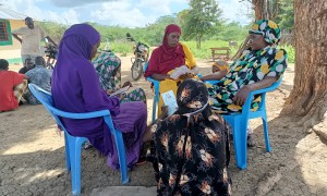
“When the river rises, we often have very little time to move our families and livestock. If we receive reliable warnings early enough, we can harvest what is ready, move our animals to safer ground, and protect our children before the floods arrive. That time makes all the difference.”
What Next?
The Hazard Atlas brings hazard, exposure and vulnerability information together in one decision-support tool. By overlaying hazard data with the locations of Concern Worldwide programme communities, critical infrastructure and ongoing resilience interventions, county departments and partners can better identify who is most at risk, where impacts are likely to occur and where resources should be prioritised before hazards escalate. While the Atlas will initially support more targeted planning in Concern programme areas, its use extends across Tana River County, helping county departments and partners assess risk, inform preparedness and guide resilience investments in other vulnerable areas.
This information can support seasonal preparedness planning, anticipatory action once agreed triggers are reached, and more coordinated decision-making across sectors. It can help identify roads likely to become impassable, schools, health facilities and water points that may become inaccessible, and farming and pastoral areas most exposed to flood impacts. These insights can guide the pre-positioning of assistance, evacuation planning, protection of critical services and targeted early action for communities most at risk.
Beyond emergency preparedness, the Atlas can contribute to longer-term climate resilience by informing land-use planning, infrastructure investment and risk reduction programming. As new information becomes available, county technical departments, working closely with communities, can continue to update and validate the Atlas so it remains relevant for future planning.
For communities living along the River Tana, this matters because the value of the Atlas lies in enabling earlier action, more targeted preparedness and stronger protection of lives, livelihoods and development gains. As climate change increases the frequency and intensity of weather-related hazards, the Hazard Atlas complements Concern Worldwide’s community-centred approach to early warning, anticipatory action and climate resilience by providing spatial evidence to support decisions alongside county systems.

 Learning Paper